Monday 28 September 2009

Chokkai san

(Chokkai seems to be more commonly spelt as Chokai but the kk like the ss of Gassan indicates that there is a kind of  glottal stop in the middle of the word so it sounds like Chaw//kai not Chaaawkaaiii and Gu//san not Gusaaan).

From Kisakata we climbed up the  road that winds up  Chokkai san from the Yamagata side. Despite the haze, the view was spectacular.  Government efforts to have people spending money by lowering road tolls and having a five day holiday were working well if the cars in the carpark there were any guide.  There were cars from literally all over Japan.  We saw vehicles from every region (except Okinawa obviously as it is closer to Taiwan and has no bridge joining it to the main islands): neighbouring prefectures, Kanto, Kansai, southern parts of the Japan sea coast, Hiroshima & surrounds,  Shikoku, as well as Hokkaido.  Hiro had never seen such an array of differently plated cars in Tohoku  - even in Tokyo the number of Tokyo plates dilutes the rest considerably.

We started climbing from the Akita side, with no intention to climb the 8 km one way to the summit.  Hiro has been here many times, and had memories of a lake part way up - we climbed for a distance but upon being told it was a steep 4km hike from the carpark made a unanimous decision to skip the lake. 8kms isn't so far but becomes a lot further when it's steep and you haven't eaten much.

We went back down and had a late lunch at a michi no eki  - kind of travellers rest / farmers market - before setting off into Akita.  We spent Tues in Odate before making a gruelling 9 hour trip back to Tokyo! Fortunately we avoided traffic congestion of all description and it wasn't 12 hours :)


Chokkai san
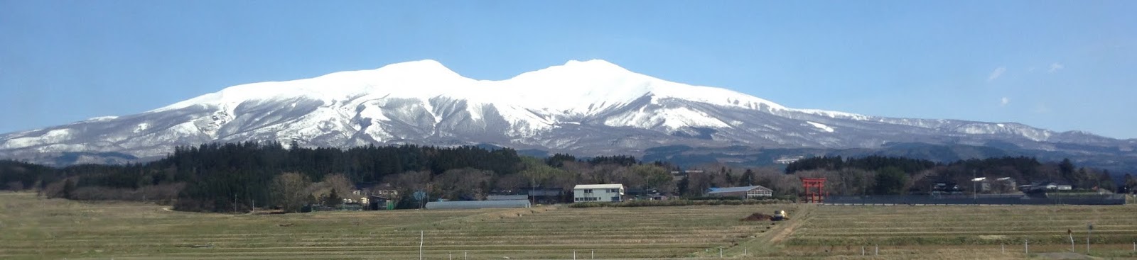
Chokkai san in late March.

Kisakata

From the waterfalls on the way up to Mt Chokkai we made our way to Kisakata, perhaps 20 mins away, in Akita prefecture.  On the seashore at Kisakata are a series of carvings made by a Yamagata based Zen Buddhist monk at the beginning of Meiji era (1864-68 they were made). There were 16 carved, I didn't count to see if any have been worn away.  They are quite impressive.  I'd not heard of them before though; an internet search in English brings up nothing and in Japanese not a whole lot.  
It's a pity Tohoku doesn't market itself better.  Part of the problem is a distinct snobbery to the region from the major cities.  Traditionally Tohoku people are considered backward and dim - American movies that have illbred, illeducated rednecks will have their voice dubbed in a thick Tohoku dialect.
People from Osaka tend to take pride in their regional dialect, whereas Tohoku people, on moving to Tokyo will quickly eliminate any trace of it.
Things may be starting to change though as people Japanese people become nostalgic for old Japan.  In Tohoku conspicious foreigners are few in number (there are many arranged marriages of rural Chinese and Filippina to Tohoku farmers but they tend to prioritise assimiliating), there are mountains, onsen, and traditional foods. 
It would be nice if Japan could take up the Italian example and have every one embracing their region and speaking their own dialect with pride, as well as speaking the standard language.  The difference in different dialects used to be the point where a person with a strong Tohuku dialect and a person with a strong Kyushu dialect (the most southern of the 4 major islands) would be mutually unintelligible.  communication between old dialects was almost complete. Hiro 's oldest uncle, who grew up 20 minutes away from Hiro speaks dialect so strongly that Hiro understands at best 80% of what he is saying!    Realistically though I don't see any kind of revival of dialects coming - they are becoming less strong and less widespread.  Language is one way of enforcing national unity, something the Chinese govt.  appreciates.


Waterfalls - ichi no taki, ni no taki

We continued along the road to a place where a walking track to ichi no taki and ni no taki (taki being waterfall) was marked.  According to the map it was about a  3 hour hike to the top of Mt Chokkai, though it would be an unorthodox way to get there - most people drive closer to the summit and approaching it from the Akita side. We were satisfied with walking along the walking path  that ran along a mountain stream with periodic waterfalls for about 45 mins or so, and opted not to branch of along a much less frequently used track that would have taken us to the summit.  It is said that climbing Chokkai san that there is no need to carry a water bottle as water is so abundant on the mountain.  After venturing along this path, I have no reason to doubt it.  

The water was very cold, good for trout fishing but miserable for swimming.  I am a wimp for water that is at sub-tropical temperatures, but even Hiro thinks it would be unsuitable for swimming all year round.  (I assume the last of the snow here would melt here in June /July.)

.

Waterfalls

At the tourist centre in Sakata we saw information about a waterfall where there were separate left and right falls that both originated as springs but the water had different tastes. The cynic in me had visions of someone standing behind it pouring chili into one stream and pepper in the other, but I was genuinely very curious.  It turned out to be not far from the place we were staying so after and early breakfast we got on the road to see it. 
The sign to the waterfall had a warning about bears next to it and despite briefly regretting not buying a bear warning bell that a hawker tried to sell us in Zao onsen, we followed the track in the waterfall.


As would be expected, a shrine had been built in between the two falls. It was simple and wooden, very much in keeping with the surrounds.  I couldn't taste much difference in the water from each side, but they were a different temperature.  Hiro could detect a difference, but explaining it was not so simple (he must need to do a wine tasting course to build up his store of adjectives ;) )

For something that is quite a curiousity, it was a surprise that there was no-one else there. It presumably is reasonably popular.  If you look at the last picture, you can see piping has been set up to make it easy for people to do a comparison in water tastes.  While the practicality is laudable, it really doesn't enhance the beauty of the area.  Hiro, with his tongue in his cheek, calls it 'Asian courteousy' - every good mountain deserves a ropeway. ;)


.


This is only for the RHS fall, the LHS fall pipes are a little to the left of the picture

Sunday 27 September 2009

Tsuruoka, Sakata, Yuza


Lunch from 7-11 and we were on our way to the beach at Tsuruoka to eat it.  Aside from its latitude it is ideally localted -   10 mins from the beach and 15 minutes from the mountains.  Hiro spent 2 of his university years based here and knows the area well, though he says the roads have changed dramatically since he was there.
The beach was peaceful, and a pleasant place to eat a bento.  Environmental considerations though haven't been at the forefront development applications thought and the hotels built virtually on the beach seem to be contributing to gradual erosion of the sand.
Winter winds blow fierce along the Japan Sea and along the road to Sakata there were thickly planted windbreaks of trees.  You can see somewhat from the picture how they all grow on an angle away from the coast line.


We stopped briefly at Sakata, a former port city in the north of Yamagata.   The Mogami river which empties into the Japan sea at Sakata, used to bring timber, rice and other goods down to Sakata for onward transportation to Kyoto and Tokyo.


The old rice wharehouses along the river in Sakata were built in consideration of the elements: the western wall has trees growing along it to keep the temperature down, and the rooves are built with space to allow air to cirucluate. The proximity to the river would have facilitated easy transportation.   JA (Japan Agriculture) retains ownership of the wharehouses today and preserves them well, though with a small museum in one end and a souvenir shop in the other, and very little in the middle.  The area has a very calm and relaxed atmophere but probably has considerably more potential.  (The picture below gives some idea of the place but doesn't do it justice at all.)


From Sakata we made our way directly to Yuza machi where we were staying the night.  Finding accommodation was a bit of a drama - the internet booking sites had every accommodation at every price level booked out on the Sunday night.  I managed to ring around and find an old school that has been recently been renovated as a school camp kind of place.  I forgot to take photos there but it was bright and fresh, high ceilings, big rooms, everything wood - quite lovely.  Hiro says often these places are built to assuage local angst at schools closing down but usually can't get the numbers to make them viable as businesses.    It was a good place to stay, though they could up the quality of their salmon at breakfast ;).

To get to Yuza we passed through many soon to be harvested rice fields.  Yamagata, like Akita supplies much of Japan's rice. (The rice photos were taking the following morning).

Yuza machi's home page accommodation information. http://www.town.yuza.yamagata.jp/Files/1/6003/html/宿泊施設一覧.html  The place we stayed at was no. 2.  - 6,000 yen or so each for dinner, breakfast and accommodation... communal bathrooms / bathtub - but we were almost the only ones there - it is mostly used for school trips.

Friday 25 September 2009

Where is Yamagata?


Knowing where Yamagata is  will make these entries make more sense.


The mountains of Dewa Sanzan are located between Yamagata city and Tsuroka. Chokkai san is close to the coast on the northern border (with Akita prefecture). The link below is a general Yamagata sightseeing link.


http://www.yamagatakanko.com/english/kokusai/index.html

Yudonosan

From Ga-san we went on to Yudono-san.
The atmosphere was quite different - unlike Gassan it was clearly a shrine (the torii below marks a shrine entrance) and had a definite money making feel to it.  In addition to the entry fee there was a 300Y bus that you could take up the mountain to the main shrine - 5 min bus or 40 min steep walk - it was a no brainer.  The  bus tickets were marked as being religious donations, which has favourable tax implications for the shrine, and were collected at the end which felt a bit dodgy.
In general it's fair to say that Buddhist temples and Shinto shrines in Japan operate as businesses and do not see social welfare as their responsibility (this is something I have a bee in my bonnet about so I am sure I will come back to it at another stage.)
We passed 2 groups of white robbed pilgrims walking down the mountain as we went up in the bus - my first impression was of the KKK...     The bus stopped next to a statue of a cow - statues of cattle are not that common at Japanese shrines; I guess as a mountain area where cropping was unviable cows assumed some degree of sacredness.  From the cow statue there was a stairway, leading down to the main shrine, flanked with signs announcing that taking photos was forbidden... it doesn't make a lot of sense to me that a mountain can be off limits to photos.   The photo ban extended to the shrine itself which was quite crowded.  (No objection to this part of the ban.)  You could pay 500Yen (6$) to take off your shoes, walk barefoot - very rare in Japan - along a path, wash your feet and come back.  I didn't particularly like the atmosphere, partly because it was crowded, and partly because it seemed purely a money making venture devoid of spirituality.  Both of us in need of something to eat, felt no need to linger. Of the 4 mountains we visited over silver week, I'd definitely rank it at the bottom.

Just as a piece of trivia, I read on Wikiepedia that in terms of the official list that grades shrines by significance, Yudono san's shrine is below both Gassan's  and Chokkai san's and on par with Haguro san's (which we didn't visit).


The torii at the entrance of Yudonosan

The cow shrine
The white bits you can see flank the walking paths - on the left down to the shrine, in the middle on a walking path inside the shrine.

Yamagata: Ga-san

We were up bright and early and after a quick dip in the onsen were on our way to Ga-san via Yamagata city.  Ga-san 月山 (which when you read it looks like Tsuki-yama or moon mountain) is one of 3 mountains, holy to Shinto, that make up Dewa Sanzan. (The three mountains of Dewa, Dewa being an old name for the region.) Had we been pilgrims we would have walked from mountain top to mountain top, fortunately we weren't.
Befitting tourists that come by motorbike, we planned to catch the ropeway part of the way up Ga-san and walk up from there, but we got there to find the ropeway under repair. The Pollyanna in me was glad they opted to repair it rather than risk a disaster on a busy tourist day.  It actually turned out to be a stroke of fortune as it was a beautiful climb with autumn leaves beginning to turn.
In addition to being a pilgrim destination, Ga-san is famed for skiing - apparently it is possible to ski here in early July.... which presumably means the pilgrimage season is very short.


Yamagata - Zao onsen Sat night

Zao is on the border of Miyagi and Yamagata prefectures. After stopping off at Zao - you can drive almost the whole way to the crater lookout - we headed down into Yamagata to Zao onsen where we stayed the night.
The road down to Zao onsen was quite lovely with autumn leaves in the higher places beginning to turn.


With its milky, sulfurous water it was plain to see why it was an onsen (hot springs) town.   The sulfur smell that hung over the town gave good reason to accept the veracity of warning signs on the public baths to take care with onsen cloths as the strong sulfur in the water would disintegrate fabric fibres.

The upside of 'famous' onsen town is, naturally, the onsen water; the down side is that the accommodation is invariably priced for the water rather than the accommodation.  (To be fair though we did book very late for a 5 day weekend.)


The place we stayed at had an onsen - the pictures of it make it look quite grubby - it was old but clean. The onsen culture there was very Tokyo (where I assume most of the guests came from) minimal eye contact, no speaking, no splashing, no bothering anyone, and minimal time spent in the onsen.   In contrast an onsen in Akita - where it is all locals using the onsen instead of the bathroom at home - there people soak, chat, do pedicures, scrub backs, in some cases sit on the floor to  scrub, stretch, do exercises, sit in every bath available, often spending an hour or even two.... perhaps the television programs in Akita aren't as good...


A quaint feature of the town was a public foot bath with excruciatingly hot water - the 8 or so year old girl sitting next to me assured me that though it was hot, I would get used to it....such wisdom...

Thursday 24 September 2009

Zao


Sat am. saw us sleep in beyond the alarm; 6 was always going to be optimistic.
When setting out, a bit before 8, most cars northbound cars were Tokyo plated, by the end of our first break however much more of the traffic was from places south of Tokyo. 1 As could reasonably be predicted, on a 5 day holiday, traffic was heavy. The information sites that give frequent updates on the 'jutai' or heavy traffic situation had little cheery news; the 'jutai' extended from Tokyo through Saitama, Tochigi, Fukushima and Miyagi with expressway traffic travelling at 30-50kms for much of the trip. A BIG bonus of motorbike travel is being able to weave through traffic at a standstill.
Turning off the Tohoku expressway at the exit for Zao less than 300 ks but 6 hours laters, we stopped for some much anticipated lunch - soba noodles.
Inspired by Japan Rail East's promotion posters from a couple of years ago,  I've been wanting to go to Zao for a long time. Could it really be as impressive as the posters?
It was. It was exactly like the posters. A comment which could be interpreted as one of disappointment, but it wasn't. It was spectacular. It was also very cold and very windy, which meant we opted not to climb to the shrine at the top. My ears were happy with the decision. It reminded me of being in Kaifeng where the Siberian winds necessitated buying a scarf to cover my head - ears- as well as one for my neck. Brrrrrr... no old ladies on the mountain selling silk scarves. Perhaps that's a business idea for when the new govt. axe Hiro's job....

Footnotes
1. Japan divides number plates into quite small areas - usually a couple for each prefecture - so you can tell with reasonable accuracy where a car is from. Just in case you are interested http://en.wikipedia.org/wiki/Vehicle_registration_plates_of_Japan.